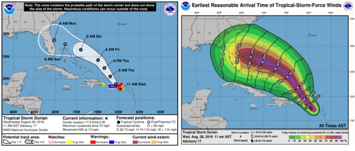

As of August 28 at 11:00 am EST, Tropical Storm Dorian is moving close to Puerto Rico and the U.S. and British Virgin Islands. Once past this area, Dorian is forecast to move to the east of the Turks and Caicos on Thursday, and track into the Bahamas by Friday. Since yesterday, Dorian has entered more moist air which has allowed it to strengthen some. Current sustained windspeeds have rapidly increased to 70 mph. Further strengthening is expected after Dorian passes Puerto Rico.
Based on current conditions, most hurricane track forecast models indicate that Dorian will remain east of Puerto Rico and the Bahamas, though these areas will certainly have an immediate impact from the storm. Once Dorian is northeast of the Bahamas a westward turn is expected, which would greatly increase the chances of Dorian making a landfall on Florida’s east coast. At this point, however, there is high uncertainty regarding which portion of the east coast Dorian could affect as conditions continue to evolve. Also, several models indicate there is a small chance that upper level steering currents could steer the event away from Florida into Georgia or the Carolinas.
The potential intensity of Dorian if it reaches the Florida coast is highly uncertain currently, especially since it remains a tropical storm for now. However, most intensity models believe Dorian will reach Category 1 intensity (at least 74 mph windspeeds) within the next 48 hours. The Risk team will continue to monitor Dorian and provide additional updates as conditions change and the storm evolves.